Hallo!
Whether due to the cyclical changing banks of Plum Run, or a change casued by deforesting the base of Big Round Top to its 1863 condition causing increased run-off, etc...
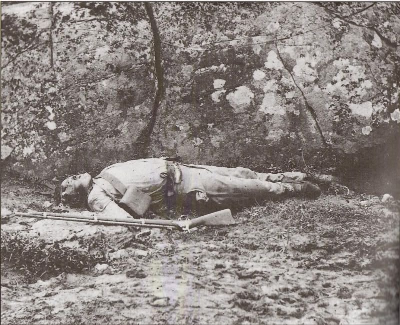
Erosion is altering the "lay of the lay" in the Alexander Gardner "Slaughter Pen" images (likely) taken July 6 or 7m 1863.
In years past, Plum Creek flowed around the split boulder curving to the viewer's left (image right) gradually carving away the high ground where the two bodies were and the edge of the "land" where Gardner set up the camera for the close-up of the second body.
However, since the deforestation, Plum Creek now has cut between the boulders carrying away most of the ground that used to extend to the split boulder (and the ground and rocks that support its one end causing the widening of the crack or split to accelerate.


Side note... NUG, the two dead Confederates are identified as belonging to either the 44th or 48t Alabama Infantry. Howeverm, IMHO, they are lying where the 4th Texas went through the valley on the assauilt on Little Round Top- on the 4th's right or on the 5th Texas' left.
Curt
(Deforestation of the base of Big Round Top in the Slaughter Pen should enable (or help) locating the sites of the dead in the other Gardner images in the winter season when the brush is not blocking the view of rocks and boulders. Just as recently with the Gardner original "Confederate sharpshooter" body location roughly 70 yards south of west down hill from Devil's Den.)
Whether due to the cyclical changing banks of Plum Run, or a change casued by deforesting the base of Big Round Top to its 1863 condition causing increased run-off, etc...
Erosion is altering the "lay of the lay" in the Alexander Gardner "Slaughter Pen" images (likely) taken July 6 or 7m 1863.
In years past, Plum Creek flowed around the split boulder curving to the viewer's left (image right) gradually carving away the high ground where the two bodies were and the edge of the "land" where Gardner set up the camera for the close-up of the second body.
However, since the deforestation, Plum Creek now has cut between the boulders carrying away most of the ground that used to extend to the split boulder (and the ground and rocks that support its one end causing the widening of the crack or split to accelerate.


Side note... NUG, the two dead Confederates are identified as belonging to either the 44th or 48t Alabama Infantry. Howeverm, IMHO, they are lying where the 4th Texas went through the valley on the assauilt on Little Round Top- on the 4th's right or on the 5th Texas' left.
Curt
(Deforestation of the base of Big Round Top in the Slaughter Pen should enable (or help) locating the sites of the dead in the other Gardner images in the winter season when the brush is not blocking the view of rocks and boulders. Just as recently with the Gardner original "Confederate sharpshooter" body location roughly 70 yards south of west down hill from Devil's Den.)


Comment